
America is the land of the road trip. Since the dawn of the automobile age, Americans have turned to their cars to seek adventure on the open roads of this vast country. Generations of Americans, from the Beats to the Millenials, have made the road trip part of not only their popular culture, but their collective psyche. The experience of driving cross-country has a grip on America’s collective imagination, and for many including myself, the only way to quell the urge is to hit the road.
My previous experience with this phenomenon, my road trip resumé if you will, consists of a multitude of minivan journeys with my family back and forth to Chicago across America’s midwest. Although I’ve been behind the wheel for years, I had yet to drive long distance by myself. My longest stint behind the wheel thus far had been a 500 mile round trip to camp overnight in Colorado’s high country. This was about to change, however. I, too, would take on the journey of a long distance, interstate road trip. Not only that, but I would be doing it for the first time alone.
A few months ago, over a beer in Denver, a friend of mine who was in the process of moving to Oregon told me about a dilemma he faced. He and his girlfriend would be driving two cars, both hers, out to their new home from Colorado. My friend’s car would remain stranded in Denver, to be delivered at a later, unknown date. As an answer to his little problem, I volunteered to drive the Hyundai (which he had named Esmerelda) over 1,400 mi (2250 km) from Denver to McMinnville, the town about 40 minutes from Portland where they would be living. The one-way ticket from Portland would save my friend time and money, and given his dislike of driving long distances, it seemed like an obvious choice. Discussion over a few more tasty beers cemented the idea, and thus the gears of an adventure were set into motion.
The plan I came up with was to drive to the Pacific over three days. My first leg would normally take me north on Interstate 25 to Wyoming, where I would turn west and go over the easy grades of South Pass through the Rocky Mountains. Instead, I decided to punch straight through the spine of the Colorado Rockies, heading up Interstate 70 and over its high passes and deep gorges, across the vast desert of eastern Utah and up Price Canyon to Salt Lake City. Day two would lead me north, past the Great Salt Lake and up to Interstate 84 through the farmlands of southern Idaho to the state’s capitol, Boise. The third and final leg would be from Boise, across the Oregon border and through the Blue Mountains, up the Columbia River Gorge, and down the valley of the Willamette River to McMinnville. At the end of the road, I had most of a day to spend on the shore of the Pacific Ocean before heading back to Denver by air. It’d be a fast four days, but at the end would no doubt be worth it. It’s not often I get the chance to get my feet wet with salt water.
One morning in May, the time had finally come to hit the road. I had all my supplies: a backpack full of trail mix and water bottles, some hiking gear in case I found something to climb, and of course my camera. All my gear had to fit in one small pack because of my return flight, so packing light was essential. Also on board were a whole road trip’s worth of WBEZ’s This American Life – my plan for the more tedious miles was to use Esme’s three 10″ subwoofers to boom Ira Glass’ soothing voice all over the western US. Today was the longest of the four, a little over eight hours’ of driving separating me from Salt Lake City. After grabbing one last dose of Denver green chile in burrito form, I headed up the hill on I-70 and into the Rocky Mountains.
The trip up from Denver, through the Eisenhower Tunnel, and over Vail Pass took the better part of two hours. I decided to stop for a bite to eat near the town of Minturn, about ten minutes from Vail on US Highway 24. Just off the highway, I found a pull off which led back to Minturn’s former rail yard. During the height of Colorado’s mining boom, the rails which pass through Minturn carried thousands of tons of ore, coal, and timber every day. Now, the railway line is only used by hikers and locals out walking their bandana-wearing mountain dogs. I decided to take a short hike up the grade myself, and just a few hundred yards from where I parked, I came across an unusual sight.
High above Minturn, a rock formation called the ‘Lionshead’ used to loom over the valley. One night in March of 2013, a huge chunk of rock broke free from the Lionshead, the result of natural geologic forces – eons of weathering and thermal expansion finally caused a crack large and deep enough to give way. With a tremendous crash that must have shaken the surrounding valley, the bus-sized rock tumbled down the side of the hill and smashed into the railway bed at the bottom. The boulder hit with such force that it dug itself a crater nearly five feet (1.5 m) deep and snapped the steel rails of the Tennessee Pass line like toothpicks. The wide shelf created by the railroad grade stopped the boulder just short of continuing its fall – directly into a few houses just down the hill!

Minturn resident George and his wife Claudia examine what he called ‘The Heart of the Lion’ along the abandoned railway grade just above this small mountain town.
I’ve lived in Colorado for the better part of my 27 years, and even though I’ve managed to see a fair amount of my home state, the sheer beauty of the Rocky Mountains never ceases to make me gawk. Interstate 70 is the largest, most direct transport corridor in the western half of the state, and it passes through some of the most scenic parts of the Colorado Rockies. Its designers took such pains that parts of this route weren’t completed until the 1990s, well after the Interstate Highway System was finished in the rest of the U.S. The civil engineering that went into this route is staggering; one only has to leave I-70 for mountain back roads for a few minutes to realize how hard a road must have been to build to accommodate four full lanes of 70 mph (110 km/h) traffic through some of the roughest terrain Earth has to offer. As I drove west, the character of the mountains themselves changed as well, with the craggy granite peaks of the central Rockies giving way to the reddish sandstone and limestone of the Western Slope.
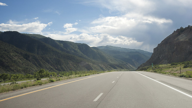
Westbound through Eagle County, high in the Rockies.
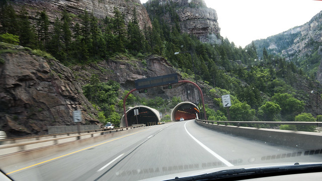
About to pass through the Hanging Lake Tunnel in Glenwood Canyon.

A mountain storm brews just west of Rifle, CO.
The shadows cast by the flat-topped mountains of western Colorado began to get longer across the highway as I pushed across the spine of North America. Western Colorado is a constantly changing landscape; from the cutting action of the Colorado River, still digging deeper into its gorges, to the innumerable fracking rigs now dotting the landscape in the never ending search for natural gas deposits. Thanks to my detour to the Heart of the Lion, I was growing short on time, and I knew I still had the vast desert of eastern Utah to cross before finally stopping for the night in Salt Lake City. I put the Colorado Rockies in my rear view and ran for the border.

By the time I reached Grand Junction, the sun had set and the last rays of light were struggling to poke over the horizon. I paused briefly, taking a walk down by the Colorado River, swollen from the torrent of spring snowmelt coming from the high Rockies. This city of roughly 60,000 people is the last major settlement for roughly 250 miles. Despite the occasional wildfire, Junction has managed to reinvent itself from a former railroad town full of wild west ranchers into the cultural center of its region. It boasts a four-year university, two newspapers, and the mind-bending terrain of nearby Colorado National Monument.
I made my first fuel stop before leaving town, brimming the tank before continuing across the immense desert of eastern Utah. I have some experience with this route, but this time, I would be the driver for the crossing. Also, with the last daylight now snuffed out, I would have to make the entire 250 mile (400 km) drive in the dark. This drive is not one to be taken lightly – the nearest town of any size was 70 miles (112 km) away, across some of the most remote landscape on the planet. With one last look across the border of my native realm to the wildlands beyond, I set off across the desert to Salt Lake City.
The desert is a strange place, especially after the sun goes down. I found out quickly that with no moon out, one gets the impression of driving through an endless tunnel. The desert at night is, to put it bluntly, very dark. Impossibly dark. So incredibly pitch dark that when I pulled off of the road and turned my lights off, the only thing I could think to compare it to was being inside a mountain – cave darkness. A thin layer of overcast blocked out even the starlight, but with no manmade light coming from the ground to reflect, even the clouds were swallowed up by the warm desert night.
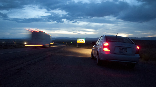
I finally found an oasis in the black, a cluster of lights shouting out into the night called Green River. With Salt Lake City still more than three hours away and the clock just past midnight, my body needed fuel to push through the fatigue I was now feeling. At this hour, the only restaurant open for business was a truck stop diner, that most noble of rural American kitchens.
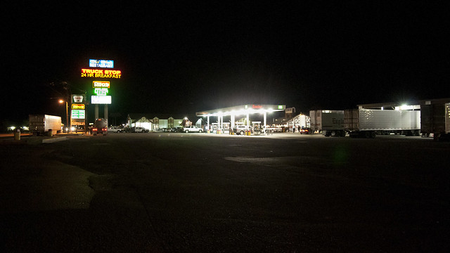
A shining beacon in the night.
I ambled in amongst the late-night crowd; some locals that looked like they’d been there every night for weeks (for all I know, maybe they had been), a few bleary-eyed truckers working on piles of pancakes and eggs before hitting the road again. The lone waitress, Bridget, looked as if she had been there since the sun was high in the sky. For everyone in the diner, this was a strange sort of halfway point, and it seemed like everyone had the air of people in transit from one place to the next. After a few cups of coffee and a burger, I was ready to once again head out. Now, however, I would be leaving the hypnotizing arrow straightness of I-70 for the twists and bends of U.S. Highway 6, a two-lane road which would cut more than 60 miles off of my route to Salt Lake. I drove out of Green River with CCR on the stereo, past a lonely State Patrolman, and up the road towards Price.
In the daytime, the scenery outside the car would be distractingly beautiful. This route skirts the edge of a 250 mile (320 km) long desert mountain range called the Book Cliffs. These sandstone cliffs stretch all the way from the rim of a canyon near Grand Junction, and in the night, I had caught up to them again where they were finally cut into by the Price River. It is these weird and wonderful landforms, towering over the flatter earth below them, that gives this place its sort of stereotypical old west atmosphere. The terrain here also helps give this highway a fearsome reputation as one of the deadliest roads in the U.S. I was confident, though, after honing my driving skill for years in the mountains of Colorado. After a little more gas, I drove out of Price and settled in for the last stretch to my hostel bed in Salt Lake.
In the night, driving with the windows down, it was hard not to feel alone on this desolate road. I passed through the entrance to Price Canyon at what must have been near 1:30 A.M., Ira Glass’ voice bouncing off the canyon walls as I drove headlong into the twists and turns of the old highway. The desert darkness was back again, but now it allowed my high-beam headlights to occasionally illuminate a tantalizing edge of canyon wall. Though this route carries huge volumes of traffic during the daytime, at night it was nearly unused. Only the occasional big rig passed me by, a few cars trailing behind waiting to make a risky pass in the dark. After what seemed like hours, I emerged from the mountains, the last of the steep ridges giving way immediately to a strange sight: a small wind farm, turbine blades swaying ghostly white in the city lights that now stretched away from the mountains. I was close now; with Highway 6 behind me, I drove north on Interstate 15. The highway slowly grew from four lanes to six, then to eight as I passed through the fringes of Salt Lake’s urban sprawl. It was now early, nearly 3.30 A.M., and at this hour I had the interstate all to myself. I drove faster than I should have the rest of the way, taking a bit of a liberty on the huge, empty I-15 in the interest of sleeping as soon as possible. Around 4, I finally rolled down the off-ramp into downtown Salt Lake City, exhausted but elated to have finally made it. Sleep would be mine!

Next time: The Great Salt Lake (it really is salty) and a fast drive through the expanses of southern Idaho.
